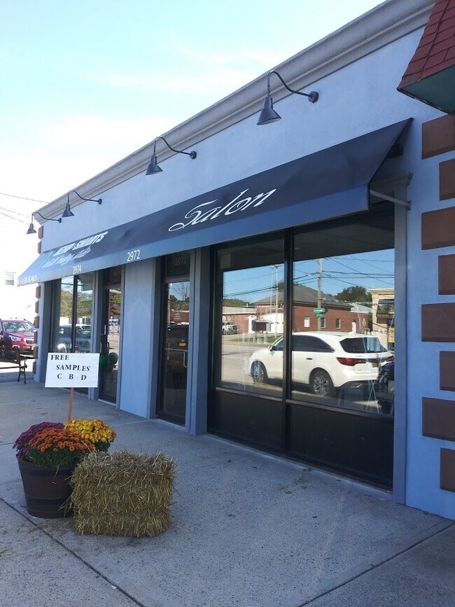
Property Record
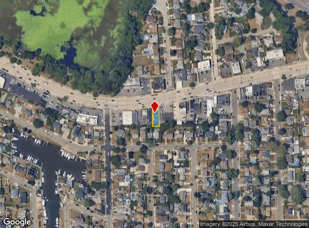
2972 Merrick Rd, Bellmore, NY 11710
NEARBY LISTINGS FOR SALE OR LEASE
Property Detail
2972 Merrick Rd
Nassau County-Suffolk County, NY
Nassau
2089-63-176-00-0095-0
New York
Townhouserowhouse
0.10 AC
X
Southeast Nassau
36059C0242G
Long Island (New York)
2,520 SF
DEMOGRAPHICS near 2972 Merrick Rd
1 Mile
3 Mile
5 Mile
2024 Total Population
17,624
128,420
364,171
2029 Population
17,295
126,030
357,310
Pop Growth 2024-2029
(1.87%)
(1.86%)
(1.88%)
Average Age
42
42
41
2024 Total Households
5,935
42,917
115,719
HH Growth 2024-2029
(2.06%)
(2.01%)
(2.01%)
Median Household Inc
$146,571
$153,756
$132,355
Avg Household Size
2.90
2.90
3.00
2024 Avg HH Vehicles
2.00
2.00
2.00
Median Home Value
$685,425
$685,199
$603,694
Median Year Built
1956
1955
1954
Nearby Places
Map Layers
Map Styles
 Street
 Aerial
- Restaurants
- Banks
- Shops
- Fitness
- Groceries
PUBLIC TRANSPORTATION
TRANSIT/SUBWAY
Wantagh Station (Babylon Branch - Long Island Rail Road)
DRIVE
WALK
Distance
Wantagh Station (Babylon Branch - Long Island Rail Road)
2 min
18 min
0.9 mi
Bellmore Station (Babylon Branch - Long Island Rail Road)
DRIVE
WALK
Distance
Bellmore Station (Babylon Branch - Long Island Rail Road)
2 min
19 min
1.0 mi
COMMUTER RAIL
Wantagh Station (Babylon Branch - Long Island Rail Road)
DRIVE
WALK
Distance
Wantagh Station (Babylon Branch - Long Island Rail Road)
2 min
19 min
1.0 mi
Bellmore Station (Babylon Branch - Long Island Rail Road)
DRIVE
WALK
Distance
Bellmore Station (Babylon Branch - Long Island Rail Road)
2 min
19 min
1.0 mi
AIRPORT
John F Kennedy International
DRIVE
WALK
Distance
John F Kennedy International
26 min
17.2 mi
LaGuardia
DRIVE
WALK
Distance
LaGuardia
36 min
24.2 mi
Long Island MacArthur
DRIVE
WALK
Distance
Long Island MacArthur
37 min
26.6 mi
Freight Ports
NY - Red Hook Container Terminal
DRIVE
WALK
Distance
NY - Red Hook Container Terminal
47 min
28.7 mi
SALE & LEASE HISTORY
LISTING DATE
SALE/LEASE

Feb 25, 2025
For Lease
Feb 03, 2020
For Lease
Nearby Properties
Address
Land Use
TOTAL SIZE
Lot Size
Zoning
Address
Land Use
TOTAL SIZE
Lot Size
Zoning
49,840 SF
729.60 AC
Address
Land Use
TOTAL SIZE
Lot Size
Zoning
20,080 SF
91.79 AC
Address
Land Use
TOTAL SIZE
Lot Size
Zoning
105,868 SF
198 AC
Address
Land Use
TOTAL SIZE
Lot Size
Zoning
4,356 SF
246.70 AC
Address
Land Use
TOTAL SIZE
Lot Size
Zoning
20,000 SF
123.34 AC
Address
Land Use
TOTAL SIZE
Lot Size
Zoning
147.58 AC
Address
Land Use
TOTAL SIZE
Lot Size
Zoning
19.88 AC
Address
Land Use
TOTAL SIZE
Lot Size
Zoning
95.90 AC
Address
Land Use
TOTAL SIZE
Lot Size
Zoning
3,900 SF
52.04 AC
Address
Land Use
TOTAL SIZE
Lot Size
Zoning
57,874 SF
21 AC
Address
Land Use
TOTAL SIZE
Lot Size
Zoning
65,235 SF
15.48 AC
Address
Land Use
TOTAL SIZE
Lot Size
Zoning
145,209 SF
20.01 AC
Address
Land Use
TOTAL SIZE
Lot Size
Zoning
9,515 SF
121.73 AC
Address
Land Use
TOTAL SIZE
Lot Size
Zoning
10,072 SF
22.75 AC
Address
Land Use
TOTAL SIZE
Lot Size
Zoning
1,500 SF
125.69 AC
Address
Land Use
TOTAL SIZE
Lot Size
Zoning
67,408 SF
66.13 AC
Address
Land Use
TOTAL SIZE
Lot Size
Zoning
120,000 SF
28.96 AC
Address
Land Use
TOTAL SIZE
Lot Size
Zoning
80,895 SF
26.22 AC
Address
Land Use
TOTAL SIZE
Lot Size
Zoning
2,145 SF
52.37 AC
Address
Land Use
TOTAL SIZE
Lot Size
Zoning
86.38 AC
Address
Land Use
TOTAL SIZE
Lot Size
Zoning
1,181 SF
25.01 AC
Address
Land Use
TOTAL SIZE
Lot Size
Zoning
81 AC
Address
Land Use
TOTAL SIZE
Lot Size
Zoning
253,201 SF
16.01 AC
Address
Land Use
TOTAL SIZE
Lot Size
Zoning
112,053 SF
16.13 AC
Address
Land Use
TOTAL SIZE
Lot Size
Zoning
65,102 SF
27.67 AC
Address
Land Use
TOTAL SIZE
Lot Size
Zoning
13,200 SF
9.44 AC
Address
Land Use
TOTAL SIZE
Lot Size
Zoning
28.33 AC
Address
Land Use
TOTAL SIZE
Lot Size
Zoning
193,285 SF
9.64 AC
Address
Land Use
TOTAL SIZE
Lot Size
Zoning
55,620 SF
19.30 AC
Address
Land Use
TOTAL SIZE
Lot Size
Zoning
60,000 SF
262.23 AC
The World's #1 Commercial Real Estate Marketplace
Connect with us
© 2025 CoStar Group
The information above has been obtained from sources believed reliable. While we do not doubt its accuracy we have not verified it and make no guarantee, warranty or representation about it. It is your responsibility to independently confirm its accuracy and completeness. Any projections, opinions, assumptions, or estimates used are for example only and do not represent the current or future performance of the property. The value of this transaction to you depends on tax and other factors which should be evaluated by your tax, financial, and legal advisors. You and your advisors should conduct a careful, independent investigation of the property to determine to your satisfaction the suitability of the property for your needs.